
by William Eric McFadden
From the West Virginia Explorer entry:
-
The 2,848-acre Jug Wildlife Management Area (WMA) ranges across river bottoms and rolling hills through fields and forests of pine and mixed hardwoods. The area is so named for "The Jug" a meander of more than four miles in the course of Middle Island Creek after which the stream nearly meets itself.
Pictures
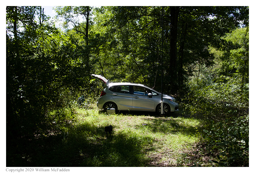
- Eric's station, with Theo-dog
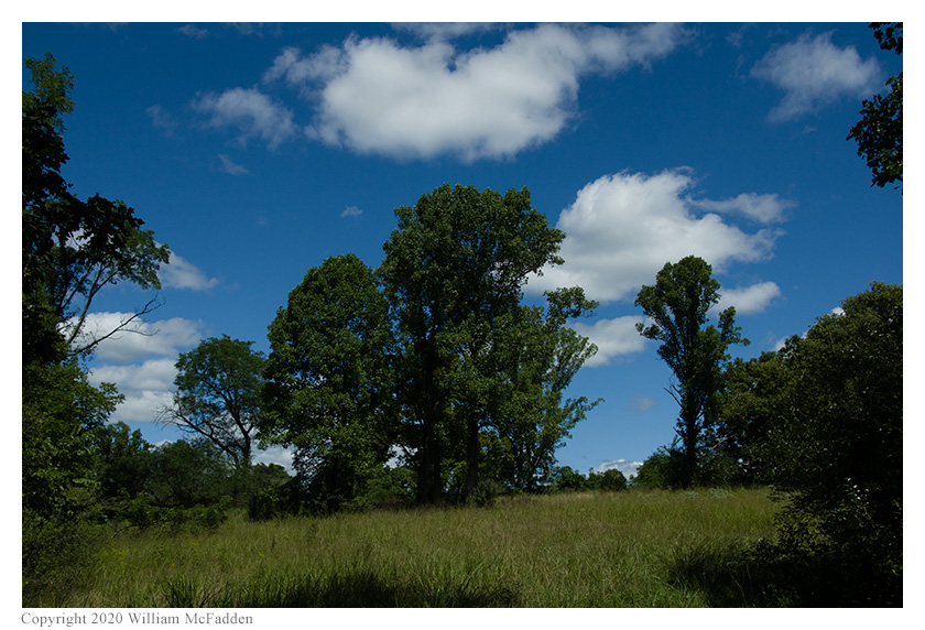
- A view of the meadow
Description
 On Sunday, August 30, 2020, one member of the Southeast Ohio Radio Adventure Team
performed a successful activation of The Jug Wildlife Management Area in West Virginia as part of the Parks on the Air (POTA; link)
program. This was the first-ever POTA activation of The Jug WMA.
On Sunday, August 30, 2020, one member of the Southeast Ohio Radio Adventure Team
performed a successful activation of The Jug Wildlife Management Area in West Virginia as part of the Parks on the Air (POTA; link)
program. This was the first-ever POTA activation of The Jug WMA.
On a beautiful late-Summer day that was perfect for outdoor radio, Eric McFadden, WD8RIF, performed the activation on Klondike Ridge in the southern portion of the WMA. Eric was accompanied by his wife Vickie and their two dogs, Theo and Mindy.
Eric had planned to perform his activation of The Jug WMA at a parking area on road 46/1 in the northern portion of the WMA. The road 46/1 turned out to be so rough it was nearly impassable to Eric's small car. Worse, level of Middle Island Creek was high and the "Low Water Bridge" across Middle Island Creek was under fast moving water and was blocked by debris. Furthermore, it was evident that road 46/1 beyond the "Low Water Bridge" was also flooded. Being unable to turn around his car, Eric reversed the short distance of 46/1 between WV18 and the "Low Water Bridge", thankful his car had a back-up camera.
 Being thus thwarted, Eric consulted the WVDNR map of the WMA and Google Maps and charted a route to a parking area on
Klondike Ridge in the southern portion of The Jug WMA, fully expecting to arrive a possible location much later than
his published start-time fort his park. The drive to and along Klondike Ridge was uneventful but no marked parking area
was found. Eric did find a pull-off leading to a scenic meadow, arriving there at about 1620 UTC. Eric quickly deployed
his 28½' wire vertical on his Jackite 31' telescoping fiberglass mast which he supported on his drive-on mount
and set up his station inside the car. Eric was on the air at 1639 UTC, only ten minutes after his announced start-time.
Being thus thwarted, Eric consulted the WVDNR map of the WMA and Google Maps and charted a route to a parking area on
Klondike Ridge in the southern portion of The Jug WMA, fully expecting to arrive a possible location much later than
his published start-time fort his park. The drive to and along Klondike Ridge was uneventful but no marked parking area
was found. Eric did find a pull-off leading to a scenic meadow, arriving there at about 1620 UTC. Eric quickly deployed
his 28½' wire vertical on his Jackite 31' telescoping fiberglass mast which he supported on his drive-on mount
and set up his station inside the car. Eric was on the air at 1639 UTC, only ten minutes after his announced start-time.
Eric was very suprised to find he had very good cell-signal at the spot and could self-spot himself on the POTA Spots website (link).
Eric began operations on 80m and his first QSO came at 1644 UTC with K8RAT in Ohio. A second QSO on 80m came immediately with AB9CA in Indiana. Eric continued calling "CQ POTA" for several minutes but no further QSOs were made on 80m.
Switching to 40m at 1648 UTC, Eric's first QSO there came at 1452 UTC with NE1D in Massachusetts. QSOs came quickly, with Eric's twelveth QSO on 40m coming at 1705 UTC with KE0TT in Minnesota. This run included a park-to-park (P2P) QSO with K4SWL who was performing an activation of Cold Mountain State Game Land, K-6895, in the mountains of western North Carolina.
Switching to 30m at 1706 UTC, Eric's first QSO there came at 1712 UTC with VA3YB in Ontario. QSOs came quickly, with Eric's eighth QSO on 30m coming at 1726 UTC with W9AV in Wisconsin. This run included a P2P QSO with K0BWR at Chase State Fishing Lake, K-7414, in Kansas and a P2P QSO with WB2MSK at Schodack Island State Park, K-2136, in New York.
Eric switched back to 40m at 1724 UTC for a P2P QSO with AA3K at Ralph Stover State Park, K-1410, in Pennsylvania. He then switched to 20m for a P2P QSO with N4CD at Chase State Fishing Lake, K-7414, in Kansas.
Eric had seen no signs marking the boundaries of The Jug Wildlife Management Area but was confident through the combined use of the WVDNR Wildlife Management Area map and Google satellite imagery that his activation was performed within the WMA boundaries.
In all, Eric made twenty-four QSOs, including five P2P QSOs. All of Eric's QSOs were CW and were made at the 5-watt level.
(return)